Archive for June, 2008

The Big Tree

Monday, June 30th, 2008

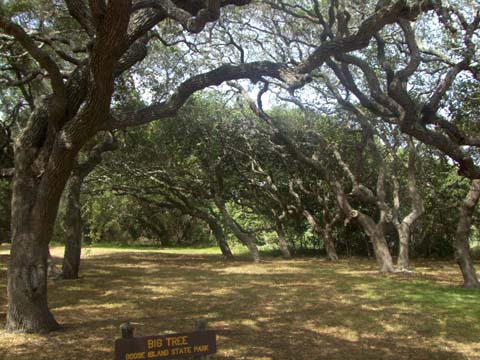
I guess I thought enough had been said about the live oak trees in the Rockport area.  Well, that was until someone said, “Have you seen the Big Tree?”

I didn’t think much more about it until I was looking at a map of the area and there was a location called “Big Tree”.  Hmm, if it rates a notation on the map, then we’d better go and take a look.

Just north of Rockport, across the Copano Bay Bridge, is the Lamar Peninsula and the Goose Island State Park.  Signs just say “Big Tree —–>” and at the end of a very narrow road, there it is.

big-oak.JPG

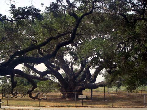
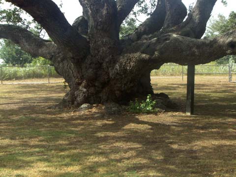
This tree is over 1000 years old and stands about 45 feet tall with a spread of about 90 feet.  The trunk, shown below, has an average diameter greater than 11 feet and a girth of more than 35 feet.

big-tree-trunk.JPG

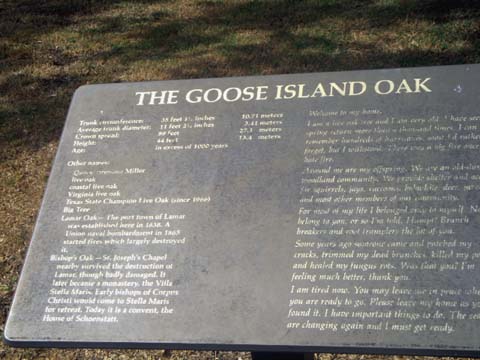
The information sign could use a little upgrade.  It hasn’t weathered as well as the tree.

big-tree-info.JPG

Strange as it might be, the Big Tree is pretty vertical.  About 40 years ago some trimming and successful disease treatments were performed on the tree.  A few cables help keep some of the branches from drooping too much.

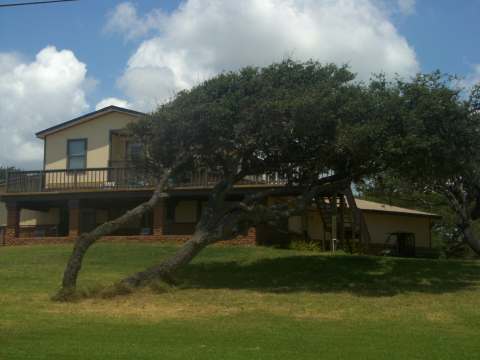
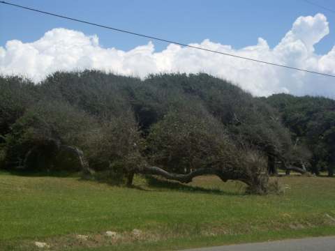
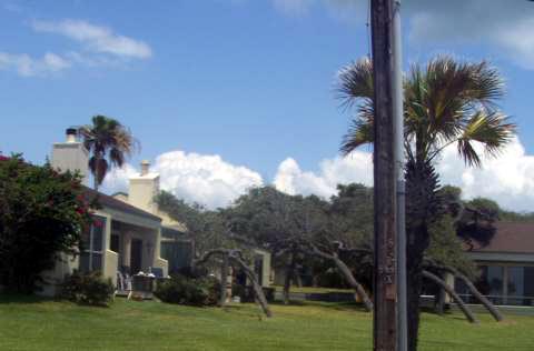
The area is full of offspring of the Big Tree.  As you can see, they don’t stand as straight as the parent.

big-tree-offspring.JPG

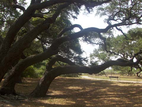
Many other decendents fill the area.

big-tree-decendents.JPG

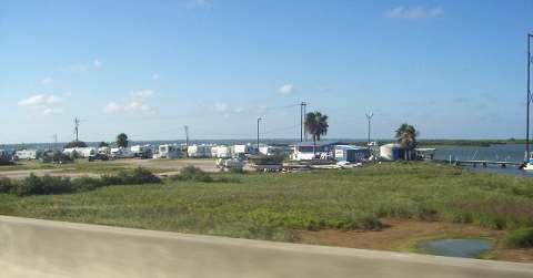
The main portion of the Goose Island State Park is located a few miles from the Big Tree. They had to contact a tree expert in Atlanta, to come trim the trees. Each time we visit the Texas State Parks we are impressed with the grounds.  They have a large, shaded area set aside for RV’s and other campers.  All of the campsites have electic and water hook ups.  A dump station is available.  The sites are quite large and private.  You can’t see your neighbor.  More to our liking were the waterfront campsites.

goose-island-state-park-rv.JPG

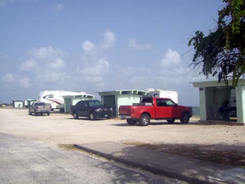
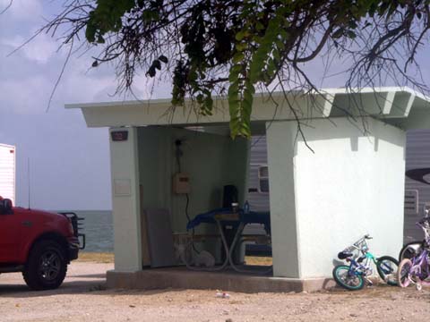
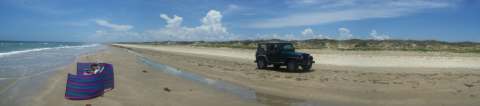
These unshaded sites are located right on the water.  Each site has a cement, lighted, covered picnic area.

goose-island-state-park-rv2.JPG

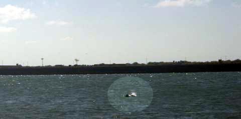
A boat launch is available and kayaks can be rented.

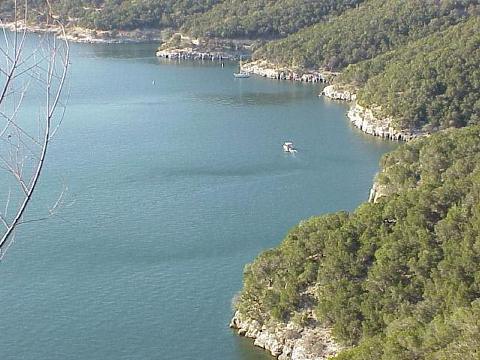
On a side note, we find several communities in this area that have built homes on canals.  The canals have access to various bays or to the Laguna Madre and the inter-coastal.

canals.JPG

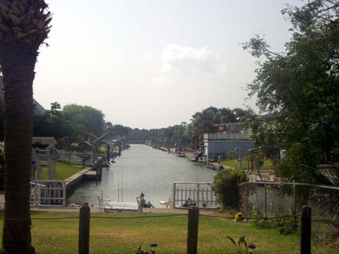
In this area, having a waterfront or water view home on the Gulf of Mexico might be nice for those that like to watch the sunrise.  We don’t get up that early.

Exploring the Central Texas Coast

Friday, June 27th, 2008

While driving along the coast, one is struck with the knowledge that THE WIND BLOWS all of the time.  Now this isn’t altogether a bad thing.  We’re not really bothered by flies and mosquitoes.

Having lived in the Dallas / Fort Worth area, we are quite familiar with the sturdy Live Oak trees.  We had to ask to be sure, but the Live Oaks along the coast take on a little different appearance.

a-tree1.jpg

You get a little different slant on the species.

a-tree2.jpg

I guess they haven’t heard about staking young trees.

a-tree3.jpg

In Rockport, along the shore of Aransas Bay,  you’ll find the Fulton Mansion.  This magnificent house was built in the late 1870’s.  When constructed, it incorporated modern conveniences such as modern plumbing and central heating.

a-fulton.jpg

Yep, they have some bent Live Oaks too.

Just south of Rockport you can catch a ferry over to Mustang Island.  Mustang Island runs about 25 miles from Corpus Christi to Port Aransas.  The ferry ride is only a few minutes long.  One wonders whether a bridge might be worth the investment.  During peak times they have 5 or 6 ferries running.  On the road to the ferry there are several rather rustic RV parks that are sitting right on the beach.

a-rv-on-beach.jpg

This isn’t a great shot because I didn’t get out of the car, but the channel is a popular place for porpoise. There were 4 in this group and they did some jumping and playing around.

a-porpoise.jpg

In order to park on the Mustang Island beach, you need to purchase a permit that is $12.00 per calendar year.  We bought one, but we noticed that only about 25% of the cars had the stickers.  You can drive on the entire beach, but there are barriers on each end of the State Park.  So, you have to exit the beach and reenter at the next park entrance.  The sand varies from firm to really loose.  The conditions change daily.

At the south end of Mustang Island there is a small bridge over a channel that leads you to Padre Island.  Padre Island runs about 70 miles south from Corpus Christi.  From Corpus Christi, you can travel south for 10-miles on the free beach  or Park Rd 22 until you reach the Padre Island National Seashore.  Once again, Tinka’s $10 National Park lifetime senior pass comes in handy.

At the entrance to the park we have a new addition, banks of security cameras.

a-cameras-2.jpg

It’s really quite impressive.  Four cameras take pictures of the front of the vehicle and four more take pictures of the rear.  These cameras operate on all incoming and outgoing vehicles.  I guess they don’t want any turtles escaping.

a-cameras.jpg

Padre Island is mostly covered with wetlands and grasslands.

a-grassland.jpg

Sunday, on our most recent visit to the park, we were shocked at what we saw.  In the few days since our last visit, the property on the Gulf side of the park road had undergone a controlled burn.

a-grassland2.jpg

Apparently this is one way to preserve the environment.  Go figure.  You can find out more at http://www.nps.gov/pais/parkmgmt/firemanagement.htm

Once you get to the beach, the beach is open to travel by only 4WD vehicles all the way to the channel at the end of South Padre Island.

During this time of year, the entire coast is traveled, by a teams of mostly volunteer Turtle Patrol.  They go by nearly every hour looking for signs that turtles have crossed the beach to nest in the dunes.  Here Tinka talks to one of the volunteers.

a-tinka-with-turtle-patrol.JPG

The volunteer said that the volunteers only travel about 15 miles south of the park entrance.  She said that this was her third year to volunteer and found a turtle nest last summer.  She did say that they have found a total of 172 so far this year on the island.   The beach farther south is covered less frequently by paid employees.  We’ve observed these Turtle Patrols throughout the Gulf and the Atlantic.  One might wonder about the resources being spent in this turtle protection endeavor.

We headed about 18 miles down the beach and found areas of the sand to be extremely tough crossing.  We decided not to go any farther until we get the winch mounted on the Jeep.  We backed up to about the 14 mile mark and found a relaxing spot to park and set up for a few hours of reading and dipping. (CLICK ON PICTURE TO ENLARGE)

a-beach-spot-480.jpg

Tinka and I enjoyed the empty beach.

Tinka spent time catching up on reading.

a-tinka-at-national-seashore.JPG

Yesterday we picked up our fishing licenses so we’ll try a little of that next week.

Finally, The Texas Coast

Saturday, June 14th, 2008

It has been a long journey from the Mexican coast, but we finally made it to the Corpus Christi, TX area.

Since we’ll be in the area for a while, our first order of business was to get ourselves to Jenny Craig to start a reduction program.  It turns out that you’re eating all the time.  It’s hard to get away long enough to do anything.  We had to rearrange our cabinets to accommodate all of the Jenny Craig food.

Our next door neighbor looks like he’ll be staying a while.  They decided on a boat rather than a park model.  Well, it is unique.

a-boat.jpg

We made it out to the beach for our maiden Jeep ride.  Here’s our new baby getting sand in her toes.

a-jeep.jpg

We covered about 30 miles of beach from Port Aransas to the entrance of the National Seashore about 10 miles south of Corpus Christi.  We haven’t quite figured it out yet, but crowds seem to gather in certain areas and then there are miles of nothing but beach.

a-beach.jpg

On Monday we’re dropping off the Jeep, in Rockport, to get the tailgate replaced and a few other dents removed.  Over the weekend, we may try to get ourselves to the National Seashore and see how far we can travel.

Hondo and The Hill Country

Friday, June 13th, 2008


We moved from Austin to Hondo, TX which is located about 40 miles west of San Antonio.  We stayed at an Escapees Park, Lone Star Corral RV Park. This park is about 8 miles west of the Hondo Wal-Mart.  Park directions on the website are not that great. LS Corral is a fairly large park and the sites are about 50 feet wide by 70 feet deep.  There is an Escapees waiting list of about 3 years to be able to purchase one of the lots.  They sell for just under $3000 plus any improvements such as decks, cement, sheds, etc.  Those little additions can add $10,000 to $20,000 to the price.

This Escapees park is pretty quiet this time of year since the busy time is during the winter.  The clubhouse is quite large and well furnished.  They have a huge library, dining area, laundry room, Wi-Fi, and craft shop.  Unfortunately, they have no pool, but with so few in attendance in the summer, it probably would be more trouble than it is worth.

Our interest in visiting Hondo and the San Antonio area was three fold.  Checking out the Lone Star Corral for possible lot ownership was one reason.  We may need another visit here in the winter to determine whether this place is too quiet for us or not.

Second, we had a chance to have dinner with Tinka’s cousin, Patricia, at the Olive Garden in San Antonio.  We hadn’t seen Patricia since our family reunion about two years ago and it was good to catch up with her.

And third, since we are heading to the coast from Hondo, we wanted to take the opportunity to search for a decent beach vehicle.  Our beach experience has taught us that a one ton dually pickup truck is a lousy replacement for a jeep.  Aside from the extreme lack of traction provided by an empty truck, the front end of the diesel is really heavy.  We found that on wet sand the 4000 pound front end will sink to the axle if we stop moving.  This results in pricey extraction efforts.

Anyway, we browsed Craig’s List for Jeep listings in the San Antonio area.  We scoped out several and found one that we wanted to see in Camp Wood, TX.  Camp Wood is located about 40 miles north of Uvalde, about 35 miles west of Hondo. 

Since we figured the best way to bargain on a car would be to have a pocketful of cash, we took the long way around in order to pass by a Wells Fargo Bank.

a-map.JPG

Hondo is located just south of what is known as the Texas Hill Country.  You can see the hills from Hwy 90.  Anyway, our little side trip took us to the hills and the sights were breathtaking.  The bank was located at Lake Medina and we found it to be a gorgeous location.

a-medina-lake.jpg

Our journey to Camp Wood took us through beautiful hills and terrain.  This is truly a place where the deer and the antelope play.  We also saw wild turkey and goats, etc.  Oh yes, and the skies were not cloudy all day.

The first town we passed through was Bandera, Tx. which is bisected by the Medina River, a popular rafting and recreation spot.

a-medina-river.jpg

We continued on, through the hills, toward Camp Wood through Vanderpool and Leakey and were happy we weren’t pulling the 5th wheel.  Mexican roads and drop-offs had nothing over this road.

a-leakey.jpg

As we dropped down into Leakey (pronounced La’-key), we came across another popular rafting area, the Frio River.

a-friorivertexas1.jpg

a-friorivertexas2.jpg

The roadside streams leading to the river were also quite picturesque.  We had expected Hondo to look like this, but not a chance.  Hondo is flat and brushy.

a-leakey2.jpg

It’s nice to have a really flexible schedule.  We arrived in Camp Wood and met up with the lady selling the 2001 jeep.  Aside from a dent in the tailgate and a small one in the front fender, the car was in pretty good shape.  They recently replaced the soft top and the AC condenser.  They even had a replacement tailgate that just needs installation and painting.  We struck a deal and with Tinka driving the jeep, we headed back to Hondo on a more direct route through Uvalde. 

After driving a dually for so long, Rick is a little more skittish about the narrow stance the the jeep provides, expecially with a stiff cross wind.

Austin – Early June

Tuesday, June 3rd, 2008


Well, we didn’t realize that we had been absent from the Austin area for probably 5 years.  The hill country of Texas is one of our favorite places and Austin is the best place to start.

The growth in the area is unbelievable.  Austin used to be a nightmare to navigate, especially in the North/South directions.  Not any more, the place is lousy with toll-roads and freeways to ease congestion.  The GPS system didn’t have all of the updates for the new roads yet.

We decided to stay at the Austin RV Park North, which is located just north of the town near Round Rock and Pflugerville.

austin-rv-north.jpg

The park doesn’t have much in the form of amenities, but they do have large, deep sites, free Wi-Fi, and a laundry room.  They are conveniently located near Exit 250 on I-35, Hwy 1, and Hwy 45. 

The Sunset is still beautiful at the Oasis Restaurant at Lake Travis.

 sunset.jpg

The restaurant had a serious fire a few years ago and is now re-opened.

Saturday we went for a swim in Lake Travis.  This is a very deep water lake and the water level is at a good high level which means that you don’t have to descend the cliffs very far to get wet.  The temperature is just about right.

laketravisoasisbluffs.jpg

The weather was gorgeous, however the wind was pretty stiff.  We left the lake around 3:30, ate, and then went out dancing.

Sunday we met some friends at the Tien Hong Chinese restaurant for Dim Sum.  It was quite good, however, because of a family spat amongst the owners, they will cease their Dim Sum in the near future.