Archive for the ‘Texas’ Category

Hurricane Aftermath and Galveston Found

Sunday, September 28th, 2008

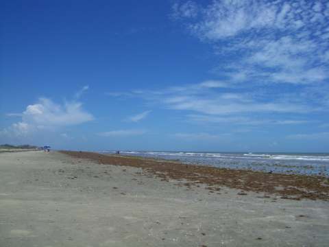
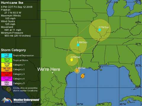
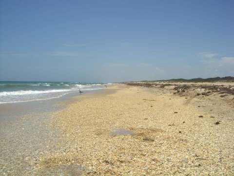
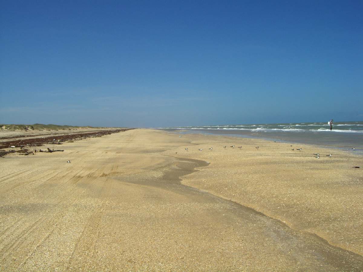
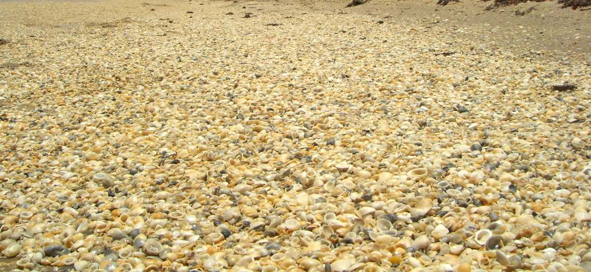
It appears that not all hurricane aftermaths are created equal.  Following hurricanes Dolly, Eduoard and Gustav we made trips to the Padre Island National Seashore (located on Padre Island just south of Corpus Christi) and were greeted with a beautiful beach and crystal clear, 88 degree, water.

a-clearwater2.jpg

GALVESTON FOUND

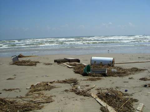
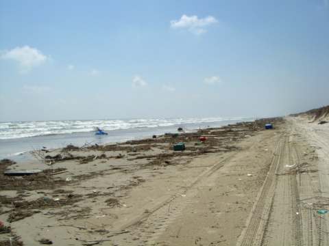
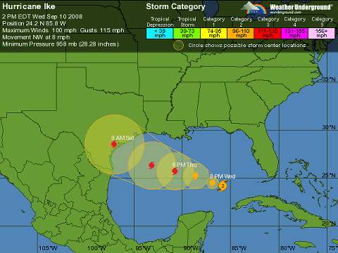
Well, following Hurricane Ike, the beach looked a little different.  We drove on the beach for about 7 miles south from the park headquarters.  We were amazed at the sight.  Under an unusually high tide, the beach was filled with trash that had washed up from Galveston over 200 miles to the north.  We were told that the beach was closed 15 miles south due to the extreme buildup of debris.

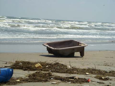
We couldn’t believe the number of Rubbermaid style storage tubs, unfortunately there were no lids.  The beach was strewn with coast guard life preservers.  Here is one of the over 20 water heaters that we saw.

a-waterheater.jpg

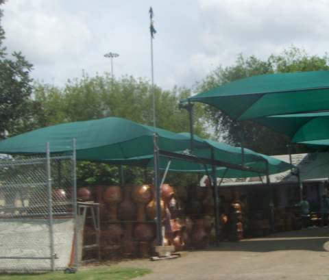
There were barrels of all kinds.  Many were marked as being owned by Texas City and the Galveston Parks Department.

a-barrels.jpg

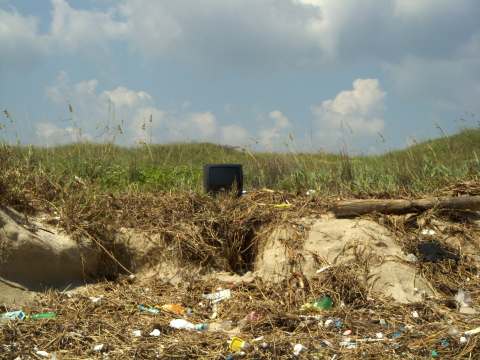
At least 4 televisions and who knew that they would float.

a-tv.jpg

Telephone poles were found everywhere.

a-telephone-pole.jpg

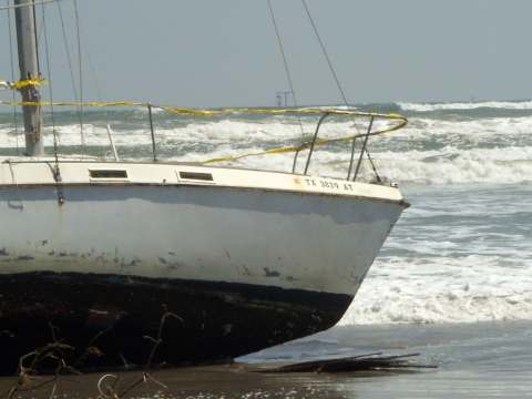
We came across a sailboat that, other than being washed onshore, appeared to have weathered the storm pretty well. 

a-sailboat1.jpg

a-sailboat2.jpg

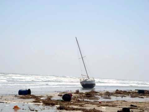
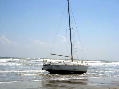
The police had ringed the boat with crime scene tape to protect the vessel until the owner can pick it up.

a-sailboat3.jpg

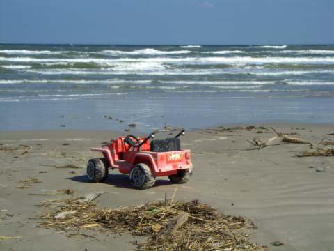
We found children’s toys

a-toy.jpg

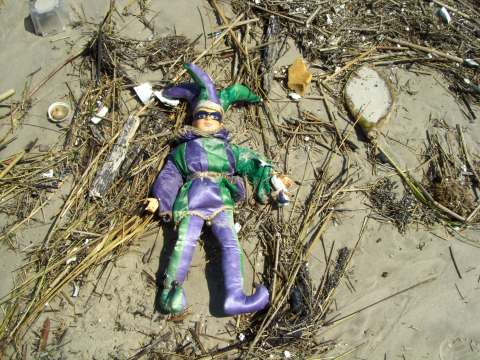
How about a Mardi Gras doll.

a-doll.jpg

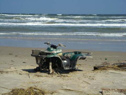
A 4-wheeler that had already been stripped of its wheels.

a-4-wheeler.jpg

Hot tub anyone?

a-hottub.jpg

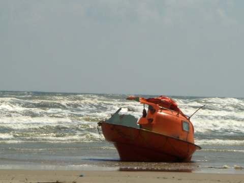
Oil rigs use escape pods as rescue devises.  If anyone was aboard this one, they may not have fared very well.  The top shell is smashed and half of it is missing.

a-escape-pod.jpg

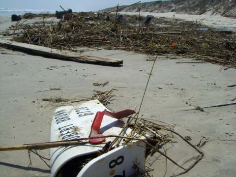
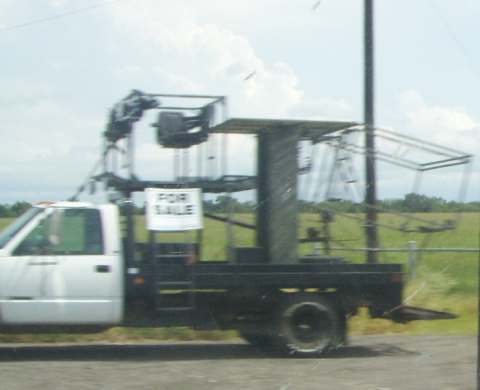
It doesn’t appear that Robert Brown will be receiving mail anytime soon.  We found this about seven miles south of the beach entrance.

a-mailbox2.jpg

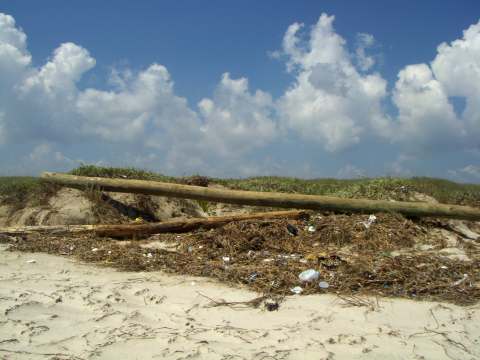
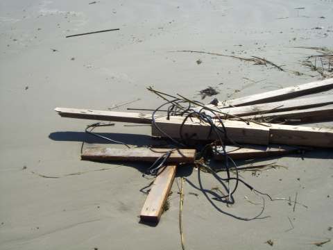
You could build several houses with the lumber that was washed ashore in the area we traveled.  There were countless staircases and roof sections.  Here are studs and rafters with the wiring still in place.

a-rafters.jpg

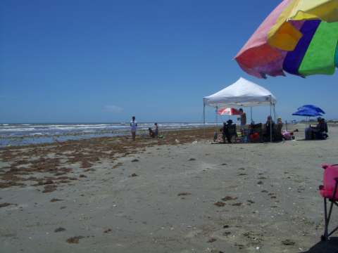
The beach was crawling with scavengers.  I’m sure that most of the salvageable stuff had already been removed.  When we left the beach we saw more people showing up with trailers for their booty.

We plan to go back next week and see how the removal is progressing.

Fleeing Ike

Friday, September 19th, 2008

Well, we’ve moved on back to Rockport on the central Texas coast.  As it turned out, we probably didn’t have to leave the area since Hurricane Ike turned north and hammered Galveston and the Bolivar Peninsula.  However, we didn’t want to take any chances.

Last year, about this time, we were leaving Florida and overwhelmed by the love-bugs that smash easily on the front of vehicles and destroy the paint.  Well, it turns out that love-bugs are pests throughout the Gulf Coast so the use of services as power pest control could really help with this.  They are not as dense as you would find in Florida, but they are certainly present near Rockport.

As we moved away from the coast, the love-bugs vanished and were replaced by swarms of butterflies all the way to Laredo.  They are still messy, but not as destructive as the love-bugs.

We had considered heading south to South Padre, but settled on going west to Laredo, Texas.  Laredo is located on the Rio Grande, about 180 miles due west of Corpus Christi.

 map.JPG

We had made arrangements to stay at Lake Casa Blanca State Park.  Because we were “evacuees”  we were allowed to stay free.  There were several people that didn’t get reservations in on time and had to “dry camp”.  In other words, find a place in a parking lot and camp without electric or water.  Luckily we had 50 Amp service and city water.  As with most of the state parks, Lake Casa Blanca had large, well maintained RV sites.  The park was quite active and has a fishing and swimming lake within its borders.

a-casablanca.jpg

We expected a small, older town.  It turns out that there are several new subdivisions to house the beneficiaries of NAFTA, the North American Free Trade Agreement. Interstate 35 terminates at the Mexican border and is a major entry point for goods being moved between Mexico, Canada, and the US.

In the older part of town we noticed a variety of businesses selling various crafts.  Here’s one with wire statuary.

a-wire-statues-2.jpg

And Pottery.

a-pottery.jpg

The buildings in the downtown area date back a number of years.

a-building-2.jpg

The building on the left has ornate tile-work.

a-building.jpg

Many of the Laredo streets were obviously designed for horse traffic rather than cars.  They are extremely narrow.

a-narrow-street.jpg

On Friday, we decided to head across the border to Nuevo Laredo, Mexico in the state of Tamaulipas.  We parked on the US side and walked across Bridge #1.  From the bridge we had a nice view of a beautiful riverside park in Laredo.

 a-border-park.jpg

Looking southeast from the bridge we see the Rio Grande and Bridge # 2.

a-river.jpg

On the south end of the bridge we found ourselves at the Mexican Point of Entry.

a-mexico-point-of-entry.jpg

Before we crossed, we asked where the good restaurants were and were told that many of them had closed.  It appeared that the streets were quite busy, but we found no upscale restaurants near the border.

a-nuevo-streets.jpg

Had we arrived a week later the place would have been crammed with people celebrating diesyseis de septembre (September 16th), which is Mexican Independence Day. You can see that the vendors in the park were getting prepared for the holiday.

a-diezyseis.jpg

We spent a few hours in Nuevo Laredo and had guacamole and a couple of beers at one of the few restaurants we found.  We left Mexico carrying a tube of arthritis cream and a couple of bottles of Bacardi Añejo which is made in Mexico and makes the best rum and cokes.

Friday night we found a very good restaraunt, the Palenque Grill, which is located near the state park at 7720 Bob Bullock Loop.  The food was excellent.  Tinka had the pollo asado and I had the sirloin steak. 

In this area, it appears that the hunters set themselves up in mobile deer stands.  We saw a number of vehicles set up with racks, and seats on the roof.

hpim8043ca.jpg

This one gave us an idea for upgrades to our jeep.  I especially like the seats mounted to the hood.

a-jeep.jpg

Sunday we made our uneventful way back to Rockport and were able to set up between rain storms.

Hurricane Season – Texas Style

Wednesday, September 10th, 2008

First things first – Happy Birthday to Tinka’s sister Jenelle!!!  We know her birthday was Sunday, and we called her but didn’t get it into a blog.  She is thrilled to be another year older.

———————————————————————————————————————

Between 1900 and 1996 there have been 36 hurricane strikes along the Texas coastline.  Only 15 of those have been major storms, category 3 or greater. These strikes have been divided with 17 storms along the upper coast, 13 in the southern section and only 6 in the mid-Texas coast where we are located.

Averages would say that we might expect a hurricane to strike the Texas coast about once every three years.  Well, we hit the jackpot this year with three already.

Hurricane Dolly

Our first encounter was with Hurricane Dolly that arrived in Texas near South Padre Island.  We had left there and moved to near Corpus Christi.  Most people think that hurricanes damage the shoreline.  In this case, the reverse is true.  The Padre Island National Seashore was impacted by the north side of Dolly.

We spend quite a bit of time in the park at a place called Little Shell Beach, located about 20 miles south of the park headquarters.

This was the width of the beach prior to Dolly.

a-shell1.jpg

You can see by the following picture that new beach has been deposited on top of the older one. (Click Photo for Larger View)

a-new-beach-480.jpg

This is how Shell Beach gets its name – click to enlarge.

a-shells-480.jpg

So no, hurricanes don’t always damage the beaches.

Hurricane Edouard

When we were in Galveston, we were inconvenienced again and our travels were chronicled on a recent blog.

Hurricane IKE

Now we’re tested once again.  We are currently threatened by our latest adversary, Ike.  As it leaves Cuba and heads toward the Texas coast, we’re not getting a very clear picture of the proposed path.  Best guess sends it directly at us just north of Corpus Christi.  Timing will be a little easier to gauge, late Friday or early Saturday and probably a category 3.

ike.jpg\

Hence, WE’RE OUTTA HERE!!!  Tomorrow morning we’re packing up and heading west to Lake Casa Blanca State Park at Laredo, TX. (Laredo is located about 175 miles west of the coast on the Mexican border.) When we checked on availability at the park we found that there were no vacancies unless we were evacuees from the storm.  Since we are, we were able to get in, and here’s the best part, free.

We’ll keep you posted on our movements.

Break’s Over

Monday, August 25th, 2008

We’re back in Rockport and have been doing nothing but watching the Olympics daily.  Our stationary activity would have been of interest to nobody except vultures.

Anyway, we had fun at Galveston with the granddaughters.  The two day interruption from tropical storm Eduoard was a real nuisance.

Again, this year, the girls were able to pretend that they were twins. (A special note:  We were notified that Gracie will be a big sister in March, 2009.  Congratulations Kiri and Justin.)

1-dresses.jpg

The only day that it rained during last year’s Galveston adventure we had planned on trying miniature golf.  Well, this year we picked a real scorcher to go and play.  Here, following another of Rick’s holes-in-one, the girls ponder(?) their next putt.

1-miniput.jpg

On Friday, Ayden’s father, Lance, showed up to enjoy the beach.  He teamed up with the girls to prepare a spot for their sand castle.

1-castle-base.jpg

This is kind of interesting.  You might note the depth of the hole.  The layer at the bottom of the hole is mud.  The sand is quite shallow.  Although there was not much damage from the recent storm, in 2005 the area suffered the wrath of hurricane Rita.  Areas of the beach along the nearby Bolivar Peninsula were damaged severely.  We found spots at the waterline that had no sand, just the slippery mud.  It was quite difficult to walk on.

Once we convinced Ayden that she wasn’t going to be eaten by fish, she decided to try the waves.

1-boogieboard2.jpg

Tinka, looking good here, showed Ayden the way to grip the board.

1-boogieboard1.jpg

Gracie and Lance wait for the next perfect wave.

1-boogieboard4.jpg

When we were in Puerto Vallarta, we saw vendors with their dolls on parachutes showing their wares.  They would stand there and the GI Joes would fly quite easily.  We found one vendor with Barbies flying and couldn’t pass them up for the girls.  This is about as far as we could get them up before Barbie broke into two pieces.

1-barbie.jpg

After the girls left on Sunday, we hung around for a few days to relax.  We headed back across on the ferry to the Bolivar Peninsula.  We were amazed to see the number of ships waiting for their turn in the ship channel.

1-ships.jpg

We were unable to drive up the beach as far as we did before the storm.  There were sections of sand and shells that were quite soft.  Our jeep was able to get through it pretty well, but there were areas of that slippery mud that we didn’t want to risk.

Eduoard brought in a new batch of seaweed to drive the fishermen nuts.  It’s amazing how much seaweed can collect on your line.  We decided not to try.

Tinka and I were able to get in a little boogie board time in.

a-tinka-with-board2ax.JPG

On Tuesday we headed back to Rockport and the Corpus Christi area.

Back to the Beach!!!

Friday, August 8th, 2008

We spent 1-1/2 glorious, rain-filled, days in Livingston with 2 of our granddaughters.  It wasn’t all a loss as we had the opportunity to drive around beautiful Lake Livingston and have lunch at Catfish King. 

On our escape from the coast we headed straight up I45, skirted Houston, and zipped north on State Route 146 to Livingston and the Escapees park.  We decided to take a more interesting trip back.  The distance was the same and the time increased by about 30 minutes. 

a-livingston-to-galvestona.JPG

This route sent us through the area that was most directly affected by Tropical Storm Edouard.  We’d like to thank our friend David for sending us this photo of the tragic wind damage caused by the storm.

a-damage.JPG

Our route took us to the town of Winnie and down to the coast and the town of High Island.  High Island is known as a fantastic bird sanctuary and receptacle for storms.  We continued down the Bolivar Peninsula to the Galveston Ferry.  Galveston Bay was quite busy.  We had to detour around a steaming freighter from Monrovia.

a-ship1.jpg

The girls enjoyed a ringside location for the 18 minute trip.

a-girls-on-ferry.jpg

We made it back to the Galveston Island State Park by about 3:30 PM where, once again, they had messed up our reservations.  All existing reservations were cancelled and re-filled from the Austin reservation center.  We’re battling once again to stay over Saturday night.  Hoping for a cancellation.

We thought we were through with seaweed.  Nope, the biggest change from Edouard was the addition of a new crop that must have been uprooted from the sea floor.

a-seaweed2.jpg

a-seaweed.jpg

The wind has died down and the water is much bluer than when we left.  We’re happy to be back at the beach and await the arrival today of Ayden’s father, Lance, who will arrive this afternoon.